|
| at: |
Homochitto National Forest |
Data from USFS GIS
 show on map
 animate
Trail users:


Elevation Profile
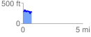
 0.723978 mi
 160.41 ft
 170.29 ft
 -9.88 ft
 4.45 %
GPX Downloads: Track Route
![]()
|
| at: |
Homochitto National Forest |
show on map
animate
0.723978 mi
160.41 ft
170.29 ft
-9.88 ft
4.45 %