| at: |
Homochitto National Forest |
Data from USFS GIS
 show on map
 animate
Trail users:


Elevation Profile
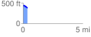
 0.352043 mi
 47.38 ft
 88.50 ft
 -41.12 ft
 4.76 %
GPX Downloads: Track Route
![]()
| at: |
Homochitto National Forest |
show on map
animate
0.352043 mi
47.38 ft
88.50 ft
-41.12 ft
4.76 %