| at: |
Homochitto National Forest |
Data from USFS GIS
 show on map
 animate
Trail users:


Elevation Profile
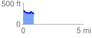
 0.867065 mi
 107.03 ft
 185.19 ft
 -78.16 ft
 4.05 %
GPX Downloads: Track Route
![]()
| at: |
Homochitto National Forest |
show on map
animate
0.867065 mi
107.03 ft
185.19 ft
-78.16 ft
4.05 %