|
| at: |
Homochitto National Forest |
Data from USFS GIS
 show on map
 animate
Trail users:


Elevation Profile
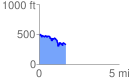
 1.673175 mi
 207.58 ft
 360.70 ft
 -153.12 ft
 4.08 %
GPX Downloads: Track Route
![]()
|
| at: |
Homochitto National Forest |
show on map
animate
1.673175 mi
207.58 ft
360.70 ft
-153.12 ft
4.08 %