| at: |
Homochitto National Forest |
Data from USFS GIS
 show on map
 animate
Trail users:


Elevation Profile
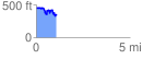
 1.076629 mi
 208.71 ft
 315.73 ft
 -107.01 ft
 5.55 %
GPX Downloads: Track Route
![]()
| at: |
Homochitto National Forest |
show on map
animate
1.076629 mi
208.71 ft
315.73 ft
-107.01 ft
5.55 %