|
| at: |
Homochitto National Forest |
Data from USFS GIS
 show on map
 animate
Trail users:


Elevation Profile
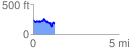
 1.255304 mi
 235.15 ft
 282.40 ft
 -47.25 ft
 4.26 %
GPX Downloads: Track Route
![]()
|
| at: |
Homochitto National Forest |
show on map
animate
1.255304 mi
235.15 ft
282.40 ft
-47.25 ft
4.26 %