| at: |
Homochitto National Forest |
Data from USFS GIS
 show on map
 animate
Trail users:


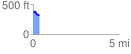
Elevation Profile
 0.374845 mi
 27.55 ft
 68.44 ft
 -40.89 ft
 3.46 %
GPX Downloads: Track Route
![]()
| at: |
Homochitto National Forest |
show on map
animate
0.374845 mi
27.55 ft
68.44 ft
-40.89 ft
3.46 %