|
| at: |
Homochitto National Forest |
Data from USFS GIS
 show on map
 animate
Trail users:


Elevation Profile
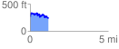
 1.207045 mi
 244.49 ft
 264.50 ft
 -20.01 ft
 4.15 %
GPX Downloads: Track Route
![]()
|
| at: |
Homochitto National Forest |
show on map
animate
1.207045 mi
244.49 ft
264.50 ft
-20.01 ft
4.15 %