| at: |
Homochitto National Forest |
Data from USFS GIS
 show on map
 animate
Trail users:


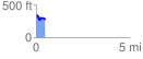
Elevation Profile
 0.461912 mi
 49.04 ft
 109.28 ft
 -60.24 ft
 4.48 %
GPX Downloads: Track Route
![]()
| at: |
Homochitto National Forest |
show on map
animate
0.461912 mi
49.04 ft
109.28 ft
-60.24 ft
4.48 %