|
| at: |
Homochitto National Forest |
Data from USFS GIS
 show on map
 animate
Trail users:


Elevation Profile
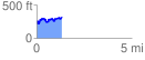
 1.369906 mi
 339.37 ft
 284.19 ft
 55.19 ft
 4.69 %
GPX Downloads: Track Route
![]()
|
| at: |
Homochitto National Forest |
show on map
animate
1.369906 mi
339.37 ft
284.19 ft
55.19 ft
4.69 %