| at: |
Homochitto National Forest |
Data from USFS GIS
 show on map
 animate
Trail users:


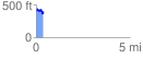
Elevation Profile
 0.393447 mi
 97.85 ft
 97.78 ft
 0.07 ft
 4.71 %
GPX Downloads: Track Route
![]()
| at: |
Homochitto National Forest |
show on map
animate
0.393447 mi
97.85 ft
97.78 ft
0.07 ft
4.71 %