|
| at: |
Homochitto National Forest |
Data from USFS GIS
 show on map
 animate
Trail users:


Elevation Profile
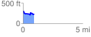
 0.913067 mi
 134.30 ft
 195.63 ft
 -61.33 ft
 4.06 %
GPX Downloads: Track Route
![]()
|
| at: |
Homochitto National Forest |
show on map
animate
0.913067 mi
134.30 ft
195.63 ft
-61.33 ft
4.06 %