| at: |
Homochitto National Forest |
Data from USFS GIS
 show on map
 animate
Trail users:


Elevation Profile
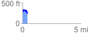
 0.419962 mi
 135.10 ft
 191.72 ft
 -56.62 ft
 8.65 %
GPX Downloads: Track Route
![]()
| at: |
Homochitto National Forest |
show on map
animate
0.419962 mi
135.10 ft
191.72 ft
-56.62 ft
8.65 %