|
| at: |
Homochitto National Forest |
Data from USFS GIS
 show on map
 animate
Trail users:


Elevation Profile
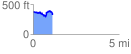
 1.130947 mi
 185.66 ft
 228.74 ft
 -43.07 ft
 3.83 %
GPX Downloads: Track Route
![]()
|
| at: |
Homochitto National Forest |
show on map
animate
1.130947 mi
185.66 ft
228.74 ft
-43.07 ft
3.83 %