| at: |
Homochitto National Forest |
Data from USFS GIS
 show on map
 animate
Trail users:


Elevation Profile
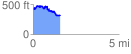
 1.571942 mi
 221.37 ft
 350.84 ft
 -129.46 ft
 4.23 %
GPX Downloads: Track Route
![]()
| at: |
Homochitto National Forest |
show on map
animate
1.571942 mi
221.37 ft
350.84 ft
-129.46 ft
4.23 %