|
| at: |
Homochitto National Forest |
Data from USFS GIS
 show on map
 animate
Trail users:


Elevation Profile
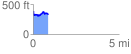
 0.868577 mi
 113.86 ft
 159.69 ft
 -45.83 ft
 3.48 %
GPX Downloads: Track Route
![]()
|
| at: |
Homochitto National Forest |
show on map
animate
0.868577 mi
113.86 ft
159.69 ft
-45.83 ft
3.48 %