| at: |
Homochitto National Forest |
Data from USFS GIS
 show on map
 animate
Trail users:


Elevation Profile
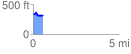
 0.582568 mi
 87.14 ft
 102.65 ft
 -15.51 ft
 3.34 %
GPX Downloads: Track Route
![]()
| at: |
Homochitto National Forest |
show on map
animate
0.582568 mi
87.14 ft
102.65 ft
-15.51 ft
3.34 %