|
| at: |
Homochitto National Forest |
Data from USFS GIS
 show on map
 animate
Trail users:


Elevation Profile
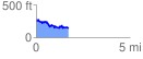
 1.726484 mi
 251.63 ft
 408.25 ft
 -156.62 ft
 4.48 %
GPX Downloads: Track Route
![]()
|
| at: |
Homochitto National Forest |
show on map
animate
1.726484 mi
251.63 ft
408.25 ft
-156.62 ft
4.48 %