| at: |
Homochitto National Forest |
Data from USFS GIS
 show on map
 animate
Trail users:


Elevation Profile
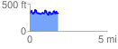
 1.848581 mi
 414.52 ft
 411.87 ft
 2.65 ft
 4.25 %
GPX Downloads: Track Route
![]()
| at: |
Homochitto National Forest |
show on map
animate
1.848581 mi
414.52 ft
411.87 ft
2.65 ft
4.25 %