| at: |
Homochitto National Forest |
Data from USFS GIS
 show on map
 animate
Trail users:


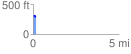
Elevation Profile
 0.184470 mi
 7.64 ft
 20.87 ft
 -13.23 ft
 2.14 %
GPX Downloads: Track Route
![]()
| at: |
Homochitto National Forest |
show on map
animate
0.184470 mi
7.64 ft
20.87 ft
-13.23 ft
2.14 %