|
| at: |
Homochitto National Forest |
Data from USFS GIS
 show on map
 animate
Trail users:


Elevation Profile
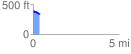
 0.385610 mi
 39.42 ft
 80.47 ft
 -41.05 ft
 3.95 %
GPX Downloads: Track Route
![]()
|
| at: |
Homochitto National Forest |
show on map
animate
0.385610 mi
39.42 ft
80.47 ft
-41.05 ft
3.95 %