|
| at: |
Homochitto National Forest |
Data from USFS GIS
 show on map
 animate
Trail users:


Elevation Profile
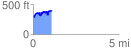
 1.063765 mi
 279.80 ft
 183.93 ft
 95.87 ft
 4.98 %
GPX Downloads: Track Route
![]()
|
| at: |
Homochitto National Forest |
show on map
animate
1.063765 mi
279.80 ft
183.93 ft
95.87 ft
4.98 %