| at: |
Homochitto National Forest |
Data from USFS GIS
 show on map
 animate
Trail users:


Elevation Profile
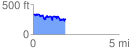
 1.921628 mi
 403.47 ft
 453.59 ft
 -50.12 ft
 4.47 %
GPX Downloads: Track Route
![]()
| at: |
Homochitto National Forest |
show on map
animate
1.921628 mi
403.47 ft
453.59 ft
-50.12 ft
4.47 %