| at: |
Homochitto National Forest |
Data from USFS GIS
 show on map
 animate
Trail users:


Elevation Profile
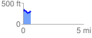
 0.607318 mi
 126.23 ft
 127.23 ft
 -1.00 ft
 3.97 %
GPX Downloads: Track Route
![]()
| at: |
Homochitto National Forest |
show on map
animate
0.607318 mi
126.23 ft
127.23 ft
-1.00 ft
3.97 %