| at: |
Homochitto National Forest |
Data from USFS GIS
 show on map
 animate
Trail users:


Elevation Profile
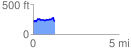
 1.259868 mi
 181.80 ft
 162.76 ft
 19.04 ft
 2.73 %
GPX Downloads: Track Route
![]()
| at: |
Homochitto National Forest |
show on map
animate
1.259868 mi
181.80 ft
162.76 ft
19.04 ft
2.73 %