| at: |
Homochitto National Forest |
Data from USFS GIS
 show on map
 animate
Trail users:


Elevation Profile
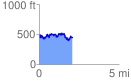
 2.091036 mi
 539.31 ft
 549.09 ft
 -9.78 ft
 4.97 %
GPX Downloads: Track Route
![]()
| at: |
Homochitto National Forest |
show on map
animate
2.091036 mi
539.31 ft
549.09 ft
-9.78 ft
4.97 %