|
| at: |
Homochitto National Forest |
Data from USFS GIS
 show on map
 animate
Trail users:


Elevation Profile
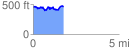
 1.772680 mi
 272.81 ft
 289.17 ft
 -16.36 ft
 3.09 %
GPX Downloads: Track Route
![]()
|
| at: |
Homochitto National Forest |
show on map
animate
1.772680 mi
272.81 ft
289.17 ft
-16.36 ft
3.09 %