|
| at: |
Homochitto National Forest |
Data from USFS GIS
 show on map
 animate
Trail users:


Elevation Profile
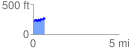
 0.699876 mi
 132.59 ft
 76.78 ft
 55.81 ft
 3.59 %
GPX Downloads: Track Route
![]()
|
| at: |
Homochitto National Forest |
show on map
animate
0.699876 mi
132.59 ft
76.78 ft
55.81 ft
3.59 %