| at: |
Homochitto National Forest |
Data from USFS GIS
 show on map
 animate
Trail users:


Elevation Profile
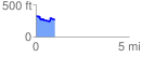
 1.025760 mi
 107.69 ft
 169.94 ft
 -62.24 ft
 3.14 %
GPX Downloads: Track Route
![]()
| at: |
Homochitto National Forest |
show on map
animate
1.025760 mi
107.69 ft
169.94 ft
-62.24 ft
3.14 %