| at: |
Homochitto National Forest |
Data from USFS GIS
 show on map
 animate
Trail users:


Elevation Profile
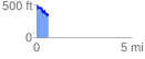
 0.601773 mi
 145.23 ft
 209.44 ft
 -64.21 ft
 6.59 %
GPX Downloads: Track Route
![]()
| at: |
Homochitto National Forest |
show on map
animate
0.601773 mi
145.23 ft
209.44 ft
-64.21 ft
6.59 %