|
| at: |
Homochitto National Forest |
Data from USFS GIS
 show on map
 animate
Trail users:


Elevation Profile
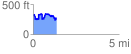
 1.359989 mi
 278.84 ft
 326.54 ft
 -47.70 ft
 4.55 %
GPX Downloads: Track Route
![]()
|
| at: |
Homochitto National Forest |
show on map
animate
1.359989 mi
278.84 ft
326.54 ft
-47.70 ft
4.55 %