| at: |
Homochitto National Forest |
Data from USFS GIS
 show on map
 animate
Trail users:


Elevation Profile
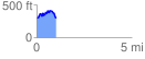
 1.030248 mi
 224.31 ft
 218.44 ft
 5.87 ft
 4.12 %
GPX Downloads: Track Route
![]()
| at: |
Homochitto National Forest |
show on map
animate
1.030248 mi
224.31 ft
218.44 ft
5.87 ft
4.12 %