| at: |
Homochitto National Forest |
Data from USFS GIS
 show on map
 animate
Trail users:


Elevation Profile
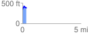
 0.334978 mi
 97.59 ft
 68.24 ft
 29.35 ft
 5.52 %
GPX Downloads: Track Route
![]()
| at: |
Homochitto National Forest |
show on map
animate
0.334978 mi
97.59 ft
68.24 ft
29.35 ft
5.52 %