| at: |
Homochitto National Forest |
Data from USFS GIS
 show on map
 animate
Trail users:


Elevation Profile
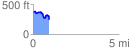
 0.943804 mi
 104.07 ft
 228.42 ft
 -124.35 ft
 4.58 %
GPX Downloads: Track Route
![]()
| at: |
Homochitto National Forest |
show on map
animate
0.943804 mi
104.07 ft
228.42 ft
-124.35 ft
4.58 %