| at: |
Homochitto National Forest |
Data from USFS GIS
 show on map
 animate
Trail users:


Elevation Profile
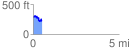
 0.503168 mi
 82.56 ft
 137.89 ft
 -55.33 ft
 5.19 %
GPX Downloads: Track Route
![]()
| at: |
Homochitto National Forest |
show on map
animate
0.503168 mi
82.56 ft
137.89 ft
-55.33 ft
5.19 %