|
| at: |
Homochitto National Forest |
Data from USFS GIS
 show on map
 animate
Trail users:


Elevation Profile
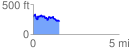
 1.547463 mi
 284.81 ft
 377.08 ft
 -92.27 ft
 4.62 %
GPX Downloads: Track Route
![]()
|
| at: |
Homochitto National Forest |
show on map
animate
1.547463 mi
284.81 ft
377.08 ft
-92.27 ft
4.62 %