| at: |
Homochitto National Forest |
Data from USFS GIS
 show on map
 animate
Trail users:


Elevation Profile
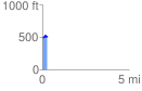
 0.275563 mi
 42.44 ft
 34.41 ft
 8.04 ft
 2.92 %
GPX Downloads: Track Route
![]()
| at: |
Homochitto National Forest |
show on map
animate
0.275563 mi
42.44 ft
34.41 ft
8.04 ft
2.92 %