|
| at: |
Homochitto National Forest |
Data from USFS GIS
 show on map
 animate
Trail users:


Elevation Profile
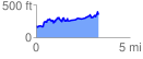
 3.339606 mi
 662.70 ft
 498.36 ft
 164.34 ft
 3.76 %
GPX Downloads: Track Route
![]()
|
| at: |
Homochitto National Forest |
show on map
animate
3.339606 mi
662.70 ft
498.36 ft
164.34 ft
3.76 %