|
| at: |
Homochitto National Forest |
Data from USFS GIS
 show on map
 animate
Trail users:


Elevation Profile
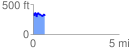
 0.690499 mi
 173.25 ft
 171.07 ft
 2.18 ft
 4.75 %
GPX Downloads: Track Route
![]()
|
| at: |
Homochitto National Forest |
show on map
animate
0.690499 mi
173.25 ft
171.07 ft
2.18 ft
4.75 %