|
| at: |
Homochitto National Forest |
Data from USFS GIS
 show on map
 animate
Trail users:


Elevation Profile
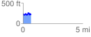
 0.682281 mi
 142.54 ft
 163.88 ft
 -21.34 ft
 4.55 %
GPX Downloads: Track Route
![]()
|
| at: |
Homochitto National Forest |
show on map
animate
0.682281 mi
142.54 ft
163.88 ft
-21.34 ft
4.55 %