| at: |
Homochitto National Forest |
Data from USFS GIS
 show on map
 animate
Trail users:


Elevation Profile
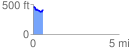
 0.564755 mi
 50.05 ft
 115.97 ft
 -65.92 ft
 3.89 %
GPX Downloads: Track Route
![]()
| at: |
Homochitto National Forest |
show on map
animate
0.564755 mi
50.05 ft
115.97 ft
-65.92 ft
3.89 %