|
| at: |
Homochitto National Forest |
Data from USFS GIS
 show on map
 animate
Trail users:


Elevation Profile
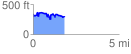
 1.840454 mi
 363.71 ft
 407.51 ft
 -43.79 ft
 4.19 %
GPX Downloads: Track Route
![]()
|
| at: |
Homochitto National Forest |
show on map
animate
1.840454 mi
363.71 ft
407.51 ft
-43.79 ft
4.19 %