| at: |
Homochitto National Forest |
Data from USFS GIS
 show on map
 animate
Trail users:


Elevation Profile
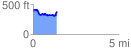
 1.406600 mi
 231.10 ft
 238.97 ft
 -7.87 ft
 3.22 %
GPX Downloads: Track Route
![]()
| at: |
Homochitto National Forest |
show on map
animate
1.406600 mi
231.10 ft
238.97 ft
-7.87 ft
3.22 %