|
| at: |
Homochitto National Forest |
Data from USFS GIS
 show on map
 animate
Trail users:


Elevation Profile
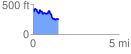
 1.482242 mi
 218.86 ft
 392.19 ft
 -173.34 ft
 5.01 %
GPX Downloads: Track Route
![]()
|
| at: |
Homochitto National Forest |
show on map
animate
1.482242 mi
218.86 ft
392.19 ft
-173.34 ft
5.01 %