|
| at: |
Homochitto National Forest |
Data from USFS GIS
 show on map
 animate
Trail users:


Elevation Profile
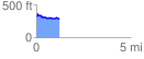
 1.201280 mi
 75.40 ft
 108.60 ft
 -33.20 ft
 1.71 %
GPX Downloads: Track Route
![]()
|
| at: |
Homochitto National Forest |
show on map
animate
1.201280 mi
75.40 ft
108.60 ft
-33.20 ft
1.71 %