| at: |
Homochitto National Forest |
Data from USFS GIS
 show on map
 animate
Trail users:


Elevation Profile
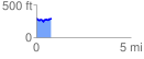
 0.799015 mi
 117.77 ft
 110.52 ft
 7.25 ft
 2.79 %
GPX Downloads: Track Route
![]()
| at: |
Homochitto National Forest |
show on map
animate
0.799015 mi
117.77 ft
110.52 ft
7.25 ft
2.79 %