| at: |
Homochitto National Forest |
Data from USFS GIS
 show on map
 animate
Trail users:


Elevation Profile
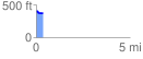
 0.360363 mi
 15.12 ft
 56.63 ft
 -41.51 ft
 2.98 %
GPX Downloads: Track Route
![]()
| at: |
Homochitto National Forest |
show on map
animate
0.360363 mi
15.12 ft
56.63 ft
-41.51 ft
2.98 %