|
| at: |
Homochitto National Forest |
Data from USFS GIS
 show on map
 animate
Trail users:


Elevation Profile
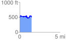
 1.487610 mi
 314.47 ft
 305.80 ft
 8.68 ft
 4.00 %
GPX Downloads: Track Route
![]()
|
| at: |
Homochitto National Forest |
show on map
animate
1.487610 mi
314.47 ft
305.80 ft
8.68 ft
4.00 %