|
| at: |
Homochitto National Forest |
Data from USFS GIS
 show on map
 animate
Trail users:


Elevation Profile
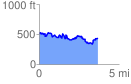
 3.748327 mi
 703.46 ft
 806.60 ft
 -103.14 ft
 4.08 %
GPX Downloads: Track Route
![]()
|
| at: |
Homochitto National Forest |
show on map
animate
3.748327 mi
703.46 ft
806.60 ft
-103.14 ft
4.08 %