| at: |
Homochitto National Forest |
Data from USFS GIS
 show on map
 animate
Trail users:


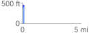
Elevation Profile
 0.155350 mi
 57.71 ft
 7.81 ft
 49.90 ft
 7.04 %
GPX Downloads: Track Route
![]()
| at: |
Homochitto National Forest |
show on map
animate
0.155350 mi
57.71 ft
7.81 ft
49.90 ft
7.04 %